
Cappadocia Fairy Chimneys: Geology and a Derinkuyu Pairing
Independent guide; not the museum operator or an official ticket seller.
Understand Cappadocia's erosion-shaped fairy chimneys through geological sources, a concept sketch and distinct viewing choices.
Last updated October 2026
Contents9
- What Cappadocia fairy chimneys are
- Rock layers, erosion and protective caps
- How rock-cut spaces differ
- Where to see a nearby example
- Pair a short stop with Derinkuyu
- Conservation and geological sources
- Choose a viewing task before choosing the stop
- Continue planning your visit
- Verdict on Cappadocia fairy chimneys
Cappadocia fairy chimneys are erosion-shaped rock forms, not built chimneys. They belong to a landscape of volcanic deposits with different properties. A cap-and-column sketch explains one common form. It does not model every pillar or date a nearby cut room.
Read the natural form and the human-cut space as separate features. Rock properties, slope and erosion help shape the pillars. Some have a distinct cap; a simple diagram does not classify them all. A room cut into a form has its own history. Choose a named, permitted viewing place rather than climb an unmarked feature.
What Cappadocia fairy chimneys are
UNESCO's Cappadocia record describes the erosion-shaped volcanic landscape and its pinnacles. It also explains the rock-cut architecture made within that setting. These are related features, but they come from different processes. Natural erosion shapes the landform. People remove rock to make a room.
The name is descriptive rather than a statement about a built flue. A pillar may look like a chimney. That shape does not prove that people built it or used it for smoke. Read the visible shape first, then the rock study. Do not turn the familiar name into a construction claim.
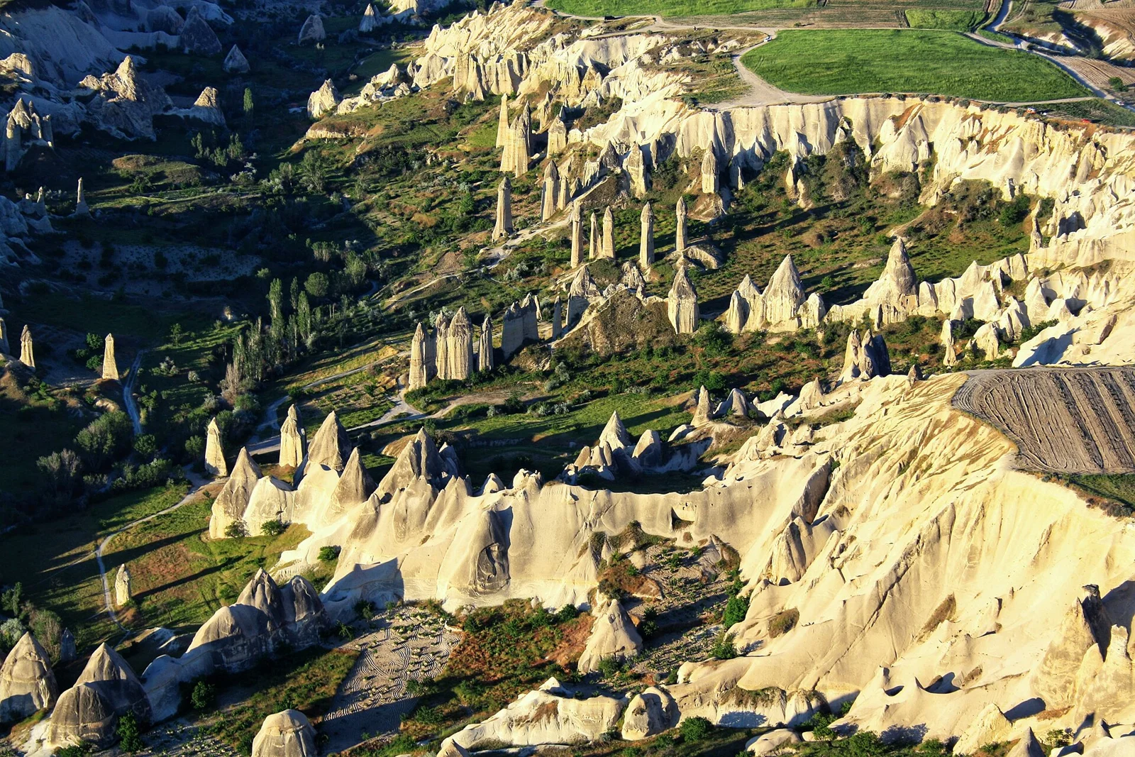
The dated hero is an aerial photo named by its creator as Love Valley. It records the rock landscape at capture, with its licence below it. It is not a generated geological reconstruction. Nor is it a route map showing where a visitor may stand today.
Rock layers, erosion and protective caps
A primary field-study abstract by Sayın and Toprak, published for the geological meeting, discusses fairy-chimney shaping in Cappadocian ignimbrites. It examines rock welding, layer thickness and slope, then local features shaping the final forms. That is a more specific basis than saying that every pillar has one identical rock sequence.
The study measured a selected sample in the field. This guide does not apply their sizes to every chimney in the region. A quoted range from one study should retain its scope. It is not a visitor-height promise for a form shown in an unrelated photo.
Different resistance to erosion can leave one part standing while rock nearby is removed. A tougher upper part can protect softer rock beneath it for a period. But the actual rocks and form need a local rock study. Not every dark-looking top should be labelled basalt from a photo alone.
The sketch below shows the simple cap-and-column idea. It leaves out exact layers, ages and erosion rates. A diagram can help explain the idea. It need not pretend to be a measured view of this place. Its caption is part of the explanation, rather than optional small print.
How rock-cut spaces differ
A doorway in a natural form can mark human work within the rock. Its date is not the date when the rock formed. Nor does it show when the whole pillar reached its present shape. Those events need separate evidence and can belong to very different time scales.
Mutlu's study of the underground cities helps with the region's rock and the rock at Derinkuyu and Kaymaklı. It does not make a fairy chimney and an underground room the same feature. A room excavated below ground and a surface pillar should keep their own source labels.
Some travel illustrations blend the two into one imagined network. A cutaway may draw rooms inside every visible pillar and links below them. Unless those spaces are recorded, the picture is an interpretation. A striking surface landscape is not proof of an unbroken underground system beneath it.
Use a room-specific source if a guide names a chapel, dwelling or storage space. A general image cannot name each opening. The proposed use and the date of that use are also different questions. A careful caption can say what is visible without adding a complete history to it.
Where to see a nearby example
The official regional tourism account names Love Valley and Paşabağ among places associated with the rock formations. These provide a named place context, checked October 2026. The account is not a current permission or path-status record for every viewing point.
Choose a viewpoint if your main aim is the landscape and your time is limited. Choose a walk only when the route and return have been checked. A photo made from the air does not name a road-accessible viewing point. A broad map pin may refer to a valley rather than the exact approach you need.
This page does not give an invented trailhead coordinate or a fixed time for all visitors. Ask a local venue or guide for the access point. Check that it is open on the day.
A museum may include rock forms on its route. Use that venue's entry rules. Do not apply them to the whole area.
Pair a short stop with Derinkuyu
Give Derinkuyu a firm visit block first. Check museum entry and the complete surface journey. Then choose a named landscape stop which fits the remaining day. A short stop is different from a full valley walk. Tell the driver which one you want.
If joining a Green Tour, read the exact stop list and what happens at each place. A landscape name in the itinerary could mean a brief viewpoint. It does not show a full walk or access inside a carved space. Ask about the actual route before adding more activities around it.
For a self-planned day, keep the return clear. A valley view with a checked pickup can fit the day. A walk with no clear return may not. That is a planning choice, not a claim about universal accessibility. The viewpoint's own approach still needs a check.
Conservation and geological sources
UNESCO describes the landscape as affected by ongoing erosion and human pressures. A form may look solid in a photo. That does not make it a place to climb. Stay on permitted paths, respect signs and avoid removing rock. Do not enter unmarked spaces to test a room reading.
The field-study abstract supplies a rock study with a stated sample and method. UNESCO supplies the wider natural and cultural context. The photo supplies a dated visual record. These sources have different jobs. Keeping them separate avoids turning a tourism image into a measured geological claim.
No erosion rate, future collapse date or age for a given pictured pillar is given here. Those would need feature-specific evidence. The lack of such a number does not stop the basic explanation from being useful. The relation between rock, terrain and erosion can be understood without invented precision.
A field sample also has a location and selection method. A study may measure a group of pillars. Ask why it chose those forms before using its findings elsewhere. A cap seen in one place may not represent all the forms around it. The study can be strong within its sample while leaving another formation outside its scope.
Try a simple task on a visit. Compare the shapes and layers you can see. Look for cut openings, but do not assign an age. Record what you can actually see. Leave the rock name to a source which identifies that local feature.
Choose a viewing task before choosing the stop
For a short landscape visit, decide what you want to observe. A distant view helps show how separate pillars sit in the wider terrain. A permitted closer path may make an individual cap or a cut opening easier to see. These views do different jobs. A striking photo may not show the best way to reach either one.
UNESCO's account treats the natural landscape and rock-cut cultural sites together. Use that relationship as a question to explore, rather than assume every pillar contains a room. You can compare natural outlines with clearly identified human openings while leaving an unlabelled hollow unexplained.
Tell a driver whether you want a brief panorama or a walk. For a panorama, agree the actual stop and pickup. For a walk, obtain the route's current access and finish point before leaving the vehicle. A valley name is too broad to settle those details.
This is particularly useful when pairing the landscape with Derinkuyu. Keep the underground visit as the fixed task, then choose a surface observation that fits the remaining day. If the closer route is unclear, use a permitted view. Do not make your own path on an unmarked slope.
Continue planning your visit
Verdict on Cappadocia fairy chimneys
Read Cappadocia fairy chimneys as natural forms shaped in a varied volcanic landscape. Keep their geological history apart from rooms cut by people. Use the sketch to grasp the idea. Choose a named viewing place with checked access.